


Run on Earth

Descrizione di Run on Earth
*** Watch this YouTube video to get to know Run on Earth!! ****http://www.youtube.com/watch?v=Cia8fWyvugQ**** Announcing the exciting new search feature that makes it a breeze to find places to exercise around the world! ****
**** Run on Earth now supports PAFERS enabled Bluetooth fitness machines! ****
Run on Earth is an exciting app that lets you enjoy the experience of exercising all over the world without ever needing to leave your home! Compatible on PAFERS enabled treadmills, exercise bikes, ellipticals and cycle trainers (with speed/cadence sensors), Run on Earth is packed with incredible features that provide an extraordinary home workout experience.
* PAFERS enabled fitness machines and equipment must be purchased separately.
** A data connection is needed at all times to use the map related features.
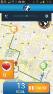
Run on Earth is integrated with Google Maps and lets you set routes around the world. The app uses elevation data provided by Google Maps and communicates with your fitness machine to simulate the real world conditions in terms of incline for treadmills and resistance for bikes and ellipticals (i.e. When going up a hill the incline of your treadmill and the resistance of your bike/elliptical will automatically increase). Now you can test your endurance with a realistic run in the challenging French Alps, or enjoy a leisurely pace along the famous beaches in Rio de Janeiro.
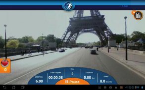
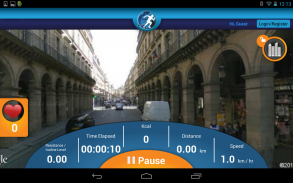
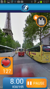
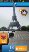
You can even use street view to see the sights just as if you were running down a real street. The lifelike experience makes it fun to set up runs all over the world and see things like the Colosseum in Rome, the beautiful coast line in Cape Town, or Central Park in New York.
**** Easily find and select routes around the world ****
- Use the new search feature to quickly find interesting and exciting places to exercise around the globe.
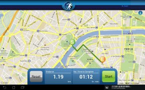
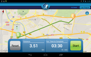
- The touch friendly design makes it easy to set up routes. Just tap on the places you want to start and end and the app will create a custom route for you.
- If you want to go down a certain street, past a park, or see a landmark, just tap on the place you want to go and the route will automatically be adjusted.
**** Integrated with Google Maps for 3 different map viewing modes ****
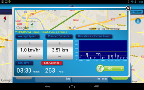
- The app communicates the map data to simulate real world conditions and will automatically adjust the incline/resistance levels for PAFERS enabled treadmills, exercise bikes and ellipticals.
- Street view lets you experience lifelike outdoor runs all over the world.
- Map view makes it easy to track your current location.
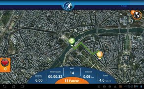
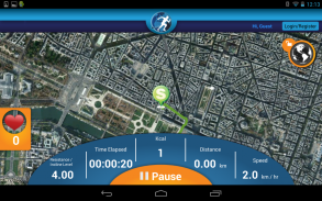
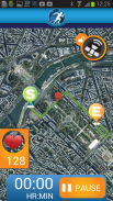
- Satellite view provides an excellent bird’s eye view of the roads and terrain you are going through.
**** Track important workout stats to accomplish goals ****
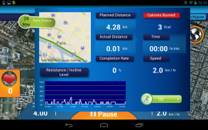
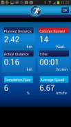
- Run on Earth tracks useful stats, including incline/resistance level, time elapsed, calories burned, km/miles traveled and speed.
- Set up a PAFERS ID so that you can save all your workout results and easily set goals and track performance.
- Multiple users can use the app to track and monitor their own results when signed in to their own PAFERS ID.
****
- Run on Earth Android version is optimised for Samsung Galaxy Note 2, Nexus 7 and Samsung Galaxy S4.
- This App is optimised to be used in the listed devices, but it also works in Android devices equipped with listed Android versions or superior, and Bluetooth 2.1 or superior, and 4.3" screen or superior.*** Guarda questo video di YouTube per conoscere Run sulla Terra! ****http://www.youtube.com/watch?v=Cia8fWyvugQ**** Annunciando il nuovo ed entusiasmante funzione di ricerca che lo rende un gioco da ragazzi trovare posti di esercitare in tutto il mondo! ****
**** Run on Earth ora supporta PAFERS abilitati macchine per il fitness Bluetooth! ****
Run on Earth è un'applicazione entusiasmante che permette di godere l'esperienza di esercitare in tutto il mondo senza mai dover lasciare la vostra casa! Compatibile su PAFERS tapis roulant, cyclette, ellittiche e formatori ciclo (con sensori di velocità / cadenza), Run sulla Terra abilitati è ricco di incredibili caratteristiche che offrono una straordinaria esperienza di allenamento a casa.
* PAFERS macchine per il fitness abilitati e le attrezzature devono essere acquistati separatamente.
** Una connessione dati è necessario in ogni momento per utilizzare le funzionalità di mappa correlati.
Eseguire sulla Terra è integrato con Google Maps e consente di impostare rotte in tutto il mondo. L'applicazione utilizza i dati di elevazione fornite da Google Maps e comunica con la macchina fisica per simulare le reali condizioni del mondo in termini di pendenza per tapis roulant e resistenza per le biciclette e le ellittiche (cioè quando salendo una collina l'inclinazione del tapis roulant e la resistenza del vostro bici / ellittica aumenterà automaticamente). Ora è possibile testare la vostra resistenza con una corsa realistica delle difficili Alpi francesi, o godere di un passo lento lungo le famose spiagge di Rio de Janeiro.
È anche possibile utilizzare street view per vedere i luoghi come se si stesse eseguendo giù una vera e propria strada. L'esperienza realistica rende divertente per impostare corre in tutto il mondo e vedere le cose come il Colosseo a Roma, la bellissima linea di costa a Città del Capo, o Central Park a New York.
**** Facilmente trovare e selezionare itinerari in tutto il mondo ****
- Utilizzare la nuova funzione di ricerca per trovare rapidamente luoghi interessanti e stimolanti per esercitare in tutto il mondo.
- Il design amichevole tocco rende facile impostare percorsi. Basta toccare i luoghi che si desidera avviare e terminare e l'applicazione creerà un percorso personalizzato per te.
- Se si vuole andare giù una certa strada, davanti a un parco, o vedere un punto di riferimento, basta toccare il posto dove volete andare e il percorso verrà regolato automaticamente.
**** Integrato con Google Maps per 3 diverse modalità di visualizzazione mappa ****
- L'applicazione comunica i dati della mappa per simulare condizioni reali e regola automaticamente i livelli di pendenza / resistenza per PAFERS tapis roulant, cyclette ed ellittiche abilitati.
- Street view consente di sperimentare piste all'aperto realistiche in tutto il mondo.
- Visualizzazione cartina rende facile rintracciare la posizione corrente.
- Immagine da satellite fornisce la vista dell'occhio un'eccellente d'uccello delle strade e del terreno che si stanno attraversando.
**** Traccia importanti statistiche di allenamento per raggiungere gli obiettivi ****
- Run sulla Terra ascolti statistiche utili, compreso il livello di inclinazione / resistenza, il tempo trascorso, calorie bruciate, km / miglia percorse e la velocità.
- Impostare un ID PAFERS modo che è possibile salvare tutti i risultati degli allenamenti e facilmente impostare gli obiettivi e le prestazioni in pista.
- Più utenti possono utilizzare l'applicazione per tenere traccia e monitorare i propri risultati quando l'accesso a loro PAFERS ID.
****
- Esegui versione Terra Android è ottimizzata per Samsung Galaxy Note 2, Nexus 7 e Samsung Galaxy S4.
- Questa App è ottimizzata per essere utilizzato nei dispositivi elencati, ma funziona anche in dispositivi Android dotati di versioni di Android presenti o superiore, e Bluetooth 2.1 o superiore, e 4.3 schermo "o superiore.


